Saturday, July 25, 2009

7-24-2009 Fri

Start point: on the Iris trail, High Point State Park
End point: Unionville, NY - the Outhouse, formerly "the Mayor's house"
miles hiked: 13.9

Wasn't in any hurry to get out early, I was anxious to get to the Mayor's house, but I knew I was gonna be hiking pretty slow because of those toe blisters. They did feel better today, the only real pain is on my left pinky toe, and it wasn't near as bad as yesterday. I stopped at the High Point State Park headquarters to get water and take a break. They have a huge monument to mark the highest point in NJ, 1803 feet.


The rest of the trail through NJ from this point runs right along the border of NJ/NY, but stays mostly on the NJ side. Got to Unionville right before a rainstorm blew in, so luckily I only got sprinkled on. The Outhouse is another one of those hostels everyone talks about and is anxious to get to. Dick started helping out hikers a couple years ago (he was the mayor of Unionville, NY for 10 years) and is nice enough to open up his home to hundreds of hikers a year. He gives you your first beer for free and the 2nd and 3rd are only .25 cents each. (Kinda bummed I'm not drinking till Aug 14th.) Feeds you dinner and breakfast and doesn't even charge, just takes donations. Met Miss Canada and Long Gun, and saw some folks I already knew: Spoonman, Many Names, Lion King, Flatlander, Boofer and Frankenfoot.


This swampy area was about a mile from Unionville, NY

7-23-2009 Thur

Start point: near Rattlesnake Mtn
End point: on the Iris trail, High Point State Park
miles hiked: 14.5

It was getting pretty painful to walk by the end of the day yesterday and today wasn't any better. Decided I would do as many miles as I could today and then try and get to Unionville tomorrow. Got down to the Brink Rd Shelter where I was gonna take a break but it was mosquito central down there. Same thing yesterday, they've been tearin me up so far here in NJ. Got up to the next ridgeline and found Dragonbreath packing up. He had got off the trail in Delaware Water Gap because of back pain and decided if he was gonna take a week off to recuperate he might as well go home where he could relax. I talked to him a few days ago and that was partly why I'd been doing so many big mile days, trying to catch up so when he got back on I'd be in the same area. Well it was great to finally catch up, hadn't seen him since Harpers Ferry, WV, but it was bittersweet. His new shoes were giving him problems, the backs of his heels were completely tore up, the skin was just rubbed raw. He was gonna have to get off the trail for at least a day, maybe more to try and get those healed up. So I hiked with him to the next road, US 206 at Culvers Gap where he was gonna try and get a ride to a motel. I hiked on and hopefully he'll catch up to me in a few days. Stopped at the Gren Anderson Shelter for lunch and to stock up on water. The place I was gonna camp tonight had no water so I had to carry enough with me for tonight and tomorrow morning. After I found a place to set up camp I drained the blisters on my toes and put some neosporin on them.

7-22-2009 Wed

Start point: Delaware Water Gap, PA
End point: near Rattlesnake Mtn
miles hiked: 22
Crossing into NJ
Went to the diner for breakfast and the SOBO's (Stumbles and Nico) let me join them. Had a power-nap after I got back to the church hostel then hiked out around 9am. Crossed the bridge over the Delaware River into NJ! The climb up was pretty nice, ran next to a creek for awhile then a real gradual climb up to Sunfish Pond, the southernmost glacial pond on the A.T. and one of the seven protected natural areas in NJ. It was one of the most beautiful areas I've seen recently.

Spent a good bit of time there just piddlin' around. Saw 7 snakes! 2 were babies, 1 baby garter snake and 1 baby water snake, another slightly bigger garter snake, and the others were all eastern black snakes

Found some good blueberry bushes that I snacked on for awhile. Stopped at the Mohican Outdoor Center for a sandwich and chips. A few of these pics are before I got to the Catfish Fire Tower, and a few of them are from the top of the tower.

Around that time I noticed the blisters forming on a few toes, so I walked in my flip-flops for awhile trying to let my feet dry out. Appearantly my feet did not appreciate doing 23 miles in the rain yesterday. Passed by Crater Lake, very pretty.


I wanted to make it to the Brink Rd Shelter but it was getting dark, so when I came across Boofer and Frankenfoot I just decided to camp with them.

7-21-2009 Tues

Start point: Smith Gap Rd, the Stempa's House
End point: Delaware Water Gap, PA
miles hiked: 23.7

Linda gave me, George and Gracie a ride back up to the trail at 5:15am. She goes to a spin class real early and it was either get a super early start, or wait till 8 or 9am when John could give us a ride. I figured if I got on the trail that early I could take my time and still make it to Delaware Water Gap and basically be done with PA. After I passed the Leroy Smith Shelter it started raining on me. I'm thinking perfect, my last day in PA and I get crappy weather. There were some good views I passed by that would have been nice if not for the fog. I stopped at the Kirkridge shelter for a couple hours trying to wait out the worst of the rain. When I finally got to Delaware Water Gap I went to the Presbyterian Church of the Mountain Hostel, no bunks open but there was a space on the floor, at least it was indoors and out of the rain. Crow and I went to the pizza place for dinner. Met some SOBO's (southbounders) at the hostel, they are basically the first ones I've seen. This guy Kyle (Stumbles) was on a submarine in the Navy and he had some of the funniest military stories I've ever heard. Also met Glow-worm and Jim Dandy, and saw Jersey Girl, Boofer and Frankenfoot again. Picked up a new book; Skin Tight by Carl Hiaasen, so I started that tonight.

7-20-2009 Mon

Start point: Bake Oven Knob Shelter
End point: Smith Gap Rd, the Stempa's House
miles hiked: 20.1

Me and Time Bomb hiked out pretty early.
When we got to PA 145 we decided we wanted to find a ride to Walnutport so we could have lunch at a buffet. The food at the chinese place we had planned on looked kinda sad, and the pizza place next door had a buffet with no pizza on it (meatloaf and hamburger helper with pasta?), so we hit up McDonalds. A couple gave us a ride back to the trail, and we made the climb out of Lehigh Gap during the hottest part of the day.
It was actually a pretty fun climb, and then we hiked through the Superfund site. This area of Blue Mtn was affected by nearly a century of zinc smelting in Palmerton, PA, and in 1982 the EPA put the affected area on the Superfund clean up list. "Revegation efforts are underway, and the mountain is slowly coming back to life."
Time Bomb's friend Michael was meeting him at the next road crossing and was getting on the trail to hike with him for a week, so we waited for him there, then they went into town to get Michael stocked up on food. After my climb out of Little Gap I had to bust a move to some Galactic
I told them I was hiking to the Stempa's, and they were gonna try and make it there as well. John "Mechanical Man" and Linda "Crayon Lady" Stempa live a mile off the trail and let hikers come to their house to get water and camp in their yard. They were home when I got there and were nice enough to let me take a shower in their house and gave me a soda. George and her dog Gracie were their, and later Crow, Time Bomb and his friend Michael showed up. They let those of us who wanted to stay in the garage sleep there,
and the others set up in the yard. Their kid and his friend were super hyper little guys and John was pretty high-energy himself. John and Linda have been helping hikers since at least the early 90's and were just all around great people. So great to find this kind of hospitality.

7-19-2009 Sun

Start point: Allentown Hiking Club Shelter
End point: Bake Oven Knob Shelter
miles hiked: 10

So that day out of Port Clinton when I was having feet problems, I called up Time Bomb and asked him if he could pick me up some sock liners if he had a chance, they were a big help to me before when I was having issues with my shoes rubbing raw spots on my feet. I had gotten a voicemail from him yesterday saying he had them and if I wanted to slow down abit he could catch up and get them to me. So I stuck around the shelter and finished my book while waiting for him. We hiked out together after he got there and later stopped for lunch at a restaurant really close to the trail, Blue Mtn B&B. We split a dozen wings and I had a black and blue burger. Later that day we ran into Coldfeet and Checkpoint. We all made it to the campsite near Bake Oven Knob, along with Free Child and Bam Bam. Funny side note, my 2 hardest climbs of the day were both to get water. At the Allentown Shelter, it was at least 6/10ths of a mile roundtrip to get to the spring that was flowing good, and at Bake Oven Knob it was around the same distance or more to get to the 3rd spring, because the first 2 were dry.

7-18-2009 Sat

Start point: Pocahontas Spring
End point: Allentown Hiking Club Shelter
miles hiked: 19.3

Hiked out around 10 or 11am, wasn't in much of a hurry because the sun had come out and I wanted to dry out my tent before I put it up, and was trying to dry out my shoes as much as I could. I was glad I stopped early last night, my heels felt ok today and wasn't painful to walk like it was yesterday. Made the climb up to the Pulpit and the Pinnacle, some of the best views in PA. Top 2 are from the Pulpit, the one with me is from the Pinnacle
Stopped at Eckville Shelter for water and decided to hike on to the next shelter. It was just me and Annunak at the shelter so we pretty much had the place to ourselves.

7-17-2009 Fri

Start point: Port Clinton, PA
End point: Pocahontas Spring
miles hiked: 2.3


So Port Clinton is just a few miles away from Hamburg, PA, where the biggest Cabela's store in the country is. If you call them they will send a shuttle to pick you up from Port Clinton, so me and Time Bomb got picked up around 9:30am. He needed to buy new shoes and I needed new socks. We both did our shopping, I got some socks and ended up with a new shirt and new pants as well (got some great deals - $12 apeice), and he got his shoes. I was hoping on making my old shirt and pants last till Maine, but in Pine Grove Furnace State Park I accidentally left my zip-off pant legs, and my shirt was getting some holes in it (plus some funk just won't wash out). It was tough to throw them away though, I'd worn those for 1200 miles! Afterward we put a hurtin' on a Pizza Hut buffet, then walked at least a couple miles to the grocery store to re-supply. A family gave us a ride back to Cabela's and we got the shuttle back to Port Clinton. All that took a good while but I still wanted to hike out, Time Bomb was gonna stay there and get a room. It started raining on my climb out of Port Clinton, and before I new it the back of my heels were burning. I think it was the combination of doing those big miles the last few days and then when my shoes got soaked on the climb up it just aggravated the problem. I decided to stop as soon as I found a campsite so I wouldn't make the problem worse. Since it was still pretty early I read most of the evening, trying to finish this book I got from the Doyle: Sleepers.

Friday, July 24, 2009

7-16-2009 Thur

Start point: 501 Shelter
End point: Port Clinton
miles hiked: 23.7
One of the odd things you see in the woods, a drinking cup box? nailed to a tree..
Me and Time Bomb made our early start as planned. Talked all day as we hiked. He is from Iowa but has made Minneapolis his new home. Him and his wife started the trail together but she got off the trail around Catawba, VA when she got sick (giardia). He was a great person to meet and just at the right time too, because I was kinda feeling kinda blue about leaving Shameless, Ziggy and Creep, and I was feeling like I'd never catch Dragonbreath since I got so far behind. Now that I'm writing this it really made me realize how much my friends out here mean to me. We're all kind of like a big support system subconsciously keeping each other going. It can be monotonous hiking miles and miles day after day, but with good friends around, to me it doesn't feel like that. When we got to Eagles Nest Shelter we took a long break, and eventually decided to make the push into Port Clinton. When we got to town the bar/grill/hotel had stopped serving food, but a really nice couple gave us a ride a couple miles up the road to Burger King, then back to town. Port Clinton allows hikers to use their town pavillon to camp under, so that was nice.
Gogonzola, Denali, Checkpoint and Coldfeet were there, as well as Beechucker. I made a big stink about BK screwing me over (no mayo!), everyone got a kick out of that.. ;)

7-15-2009 Wed

Start point: Yellow Springs Village Site
End point: 501 Shelter
miles hiked: 22

Shameless came along just as I was getting done packing up. They had all camped about 3 miles back. Ziggy showed up next and we all hiked out seperately and met up again near Rausch Creek where we all had lunch. They were all talking about going to a motel with a pool today, but I really wanted to make some miles so I resisted the urge to join them. When I got to Swatara Bridge, right near where the trail runs under I-81 there was a college aged girl and a photographer taking somewhat risque photos. I talked to her and she had been doing modeling the last couple years, so that was kinda funny to me, I just ran across a photo shoot on the AT. Typical of what you'd imagine, hot girl, creepy looking dude with a camera. This 501 Shelter that I decided to try and make it to was pretty interesting, it is fully enclosed with a sunroof, a solar shower out back, a caretaker that lives in a house next to it, and talk of a pizza place that would deliver there. I found out the number of the pizza place from the register in the shelter before it and called, they only delivered till 9. It was 7:30, so I hauled ass and made it 4miles in an hour, basically speed walking (not easy with a 30+pound pack and rocky terrain). Got there in time, ate a whole 14inch medium with pepperoni and bell pepper. Lots of familiar faces staying there, Manimal had a guitar and played some tunes while everyone was sitting around the fire. He let me do my song and it actually came out better than it ever has. Me and Time Bomb talked some and made a plan to hike out together early the next morning. The caretaker was a nutjob, he had a gun holstered on his belt, wouldn't let anybody burn their pizza boxes (but said we could throw em in the street for all he cared, as long as it wasn't on park property), and before I got there I was told he was bragging about using mace on some hikers last year that broke the rules.

7-14-2009 Tues

Start point: Clarks Ferry Shelter
End point: Yellow Springs Village Site
miles hiked: 19.7

Shameless made it out of camp first with me shortly behind. We all stopped at Peters Mtn Shelter for lunch. Big climb up Stony Mtn that I think kicked all our butts. Everyone was talking about going big miles today but I'm the only one that stuck to my guns and hiked on ahead. I ended up camping there alone but I didn't mind, it was a nice spot, the area used to be an old mining village that dated back to the 1800's. I made a huge fire and messed with it for a good while then read till I fell asleep.

7-13-2009 Mon

Start point: Duncannon, PA
End point: Clarks Ferry Shelter
miles hiked: 4.5

I know, I know, 2 zeros and then I just hike 4 miles out of town!? I'm tellin ya, the Doyle has a very strong vortex. Shameless, Creep, Ziggy, Free Child, Hot Feet and I all camped out in and around the shelter, joking around the fire and glad to be back on the trail.

7-11 and 7-12-2009 Sat and Sun

Well I had planned on taking a zero so I could get to hang out with Ziggy today. He didn't get in till around 3 or so. Me, Ziggy and Creep all ended up sharing a room so it was really cheap. Thats how I got sucked into the vortex and spent yet another zero there the next day. Breakfast across the street at the diner and dinner down the street at the pizza place, just a taste of small town PA..
Met LOTS of people over the weekend, Time Bomb, Free Child, Manimal, Aquafresh, Asop and Annunak just to name a few.. And me Ziggy, Creep, Shameless, Free Child and Hot Feet hung out alot. me and Ziggy's dance-off at the doyle

7-10-2009 Fri

Start point: near Scott Farm
End point: Duncannon, PA
miles hiked: 15.8

Got a REAL early start, since I was camped in the middle of the trail I set my alarm for 5:30am so I could be up before anyone came along. Was pumped about getting to Duncannon today so I could check out the Doyle Hotel, a dump of a hotel that is almost legendary among thru-hikers. It is one of the original Anheuser-Busch hotels and is more than 100 years old. Got a great view of Duncannon from the mountain right before you descend into town.

Got there and Denali and Gorgonzola were there, I was hoping I'd catch them. They had gotten in yesterday but were taking a zero today. Met Coldfeet and Checkpoint, they had been hiking with them for awhile. Turns out the Doyle was a dump, but its an AWESOME dump, with alot of character, and characters..

7-9-2009 Thur

Start point: north of Pole Steeple
End point: near Scott Farm
miles hiked: 25

Pretty uneventful day other than passing through Boiling Springs. A good bit of hiking through hedgerows and farmland. Through a land aquisition program they have taken most of the trail off the roads through this heavily developed area, but it still makes for a hot walk in the summer, limited shade means the sun gets to bake you. Did find quite a few wild berries today. When I got to US 11 I was gonna walk down and get some food, that ended up being about a 3 mile round trip for some Arby's (5 roast beef sandwiches for $5 though). My feet were burning by the time I got back to the trail, plus it was dark, so I hiked about another hour till I finally just found a flat spot on the trail and camped right there in the middle of it.

7-8-2009 Wed

Start point: Birch Run Shelter
End point: north of Pole Steeple
miles hiked: 14
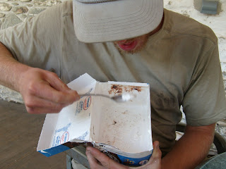
Ziggy showed up while I was packing up and eating. We hit the half-way point today (1089 miles) so to celebrate making it half way it is tradition to eat a half gallon of ice cream. I hiked ahead but promised I would wait for Ziggy to get there before I started the challenge. At Toms Run Shelters I stopped to do some push-ups (work up an appetite), and the floor of the shelter was so well varnished I tried some break-dancing as well (sad attempt, I know).

Got to the Pine Grove General Store in the State Park and Beechucker and Fish Sticks were there (not doing the challenge [lame]). They stuck around to watch me and Ziggy, we kind of made the challenge into a race between the 2 of us. They had Hershey's Ice Cream, which I'd never had before. We both got the Moose Tracks flavor, which was vanilla with pieces of fudge and little peanut butter cups in it. I finished (3500 calories later) in 20mins30secs, Ziggy shortly behind me at 22mins. We sat around and veg'd out for awhile (at least an hour), then both ate a burger and shared some fries (more food! what were we thinking). We then walked just a short way over to a beach they had made on the shore of a lake and sat around there for another 30 mins or so. Eventually got going and hiked till we found a good camp spot on the side of the trail. Made a really good fire, lots of very dry wood around the spot we had.


The old midpoint marker (mileage is wrong now)

Saturday, July 11, 2009

7-7-2009 Tues

Start point: Caledonia State Park
End point: Birch Run Shelter
miles hiked: 10

Waited around most of the morning for Ziggy. I had got ahead of him yesterday. He had been planning on going to the pool at Caledonia State park, and I was hoping he would convince me to go. He showed up around noon and even though they didn't have a diving board I made the decision to go. We hung out at the pool most of the day, and Fish Sticks showed up a few hours later and hung out too. I hiked out around 4pm and made it to Birch Run shortly before dark.

7-6-2009 Mon

Start point: near Pen Mar County Park
End point: Caledonia State Park
miles hiked: 18

Crossed into Pennsylvania today! I guess I should add I got lost and did 4 miles of road walking. The trail crossed a country road and looked like it went directly into the woods on the other side of the road, but turns out that was not the right way. I could have gone back and tried to find the right trail, but stupidly (I'm stubborn) I just kept going and figured I'd hit it. Nope. Well I came out on another road and with a little help from my mom and google maps I just walked (tried to get a ride, no one would pick me up) the 4 miles to the state park. Once again, road walking sucks, hurts way worse than walking on the trail. Once I found the trail again I walked 3/10ths of a mile down US 30 to a pizza place only to find it already closed, so I walked another 4/10ths to a little general store. The quart of chocolate milk, 2 cans of soda, cheese and crackers, chips, and ice cream cookie sandwich brightened my day abit. Road walked back down to the state park and found a stealth site to camp for the night.

7-5-2009 Sun

Start point: Ensign Cowall Shelter
End point: near Pen Mar County Park
miles hiked: 10

The big news today was making it to Pen Mar County Park where they have a Sun afternoon dance for seniors in the pavilion, with a live band. Ziggy was real excited about seeing old people dance, and I was hoping I could find a single lady to dance with. They also have a snack bar so we were banking on burgers and fries. I made it in time and did get a dance! We hung out later with Creep, Bone Lady, and Uncle Bivy Sack, stayed at the park and watched the sun set, then hiked just a little bit out of the park (no camping allowed there) and found a spot to spend the night.

7-4-2009 Sat

Start point: Pine Knob Shelter
End point: Ensign Cowall Shelter
miles hiked: 8

When I woke up and went over to the shelter I found Ziggy there, he had just hiked in and stopped there for a snack. I didn't expect to see him so that was a nice surprise. We hiked together to the next shelter and celebrated the 4th by making a big fire.

7-3-2009 Fri

Start point: Horsepen Branch
End point: Pine Knob Shelter
miles hiked: 10

My feet are killing me. I can't believe how much harder this is on your feet than the AT. Met some guys at the next campsite (Chisel Branch) and talked to them for awhile. They had come out to camp and relax during the 4th of July weekend. I got to Whites Ferry, which is the last ferry to still operate on the Potomac, getting vehicles across from Maryland to Virgina. I decided I was gonna try and get a ride across and then up to Point of Rocks, to skip about 15 miles ahead. The guys I rode with took me about a mile up to Hwy 15, then I got a ride from a really nice guy named Luke who ended up taking me to where the AT crosses over I-70. Thanks Luke! I decided that hiking all the way to Harpers Ferry on the C&O would be too painful on my feet and every day I'm on it my friends are getting farther and farther ahead of me. I hiked 35 miles of it and that was enough for me. It was a cool experience though, hiking from the Whitehouse to the woods. A 1/2 mile from where I got dropped off there was a restaurant called the Dogpatch Tavern, so I walked over there and got a sandwich and some nachos, met a hiker named Cleats. We both stopped at the Pine Knob Shelter for the night.

7-2-2009 Thur - the C & O Canal

Start point: the Boathouse at Fletchers Cove
End point: Horsepen Branch
miles hiked: around 24

Got up super early and hiked out, made it to Great Falls around noon. The Potomac River narrows from nearly 1000 feet, just above the falls, to between 60 and 100 feet wide as it rushes through Mather Gorge, a short distance below the falls. All this was carved after the last ice age when the ocean levels dropped, forcing the Potomac to carve deeper into the rock in its path to the sea. Getting to see Great Falls has been one of the most impressive things to see, and only fifteen miles from the nations capital. After hiking another couple hours I realized this is alot harder on your feet than the Appalachian Trail. Its almost like road walking, I'm guessing this path is a blast to ride your bike down, but not so fun to hike. Lots of great views of the Potomac river along the way.

Wednesday, July 1, 2009

7-1-2009 Wed

I'm sad to have to go, I was having a great time. I think Philly is pretty cool and I think my friends will enjoy living there. Its been great getting to spend some time with them, hopefully after my hike is done I can stop through again on my way south. Headed to D.C. later this afternoon.

Took the Chinatown Express back to D.C., met Chioma who I was sitting next to, it was good to meet you Chioma! When I got to D.C. I had missed the last train to Harpers Ferry so I decided to start walking the C & O Canal (Chesapeake and Ohio). It goes from D.C. to Cumberland, MD, 184.5 miles alongside the Potomac River the whole way. In 1971 Congress established it as a National Historic Park and opened the towpath next to the canal to hiking and bicycling. There are hiker-biker overnight campsites for tent camping at five mile intervals between mileposts 16.6 and 180. I had heard some fellow hikers talking about doing the hike from D.C. to Harpers Ferry (about 60 miles), so they gave me the idea, but wasn't sure if I was going to do it or not until today. I walked from the bus stop to the Whitehouse, stopped and had a few pints at a bar nearby, then headed to the start of the canal. At the beginning the towpath is on one side, then for abit there are path's on both sides, and basically I ended up on the wrong side (it was already dark at this point which might have had something to do with it). The side I was on took me up to the road (Canal Road) where there was no sidewalk, no shoulder, and being the stubborn hiker that I am I didn't wanna walk all the way back to the last bridge I passed to get on the other side. I finally made it to the Boathouse at Fletchers Cove where I found a spot on the bank of the Potomac to set up my tent. I thought I had such a great spot, then in the middle of the night I felt something wet.. Sat up and realized the river had risen and now half my tent was in the river! Luckily most of my stuff was in the front part of my tent which wasn't in the water yet, so I pulled everything up a good 10ft from the water and re-setup there. One of the more hilarious things thats happened to me out here.

6-30-2009 Tues

Mostly we just hung around the house, relaxing. My time in Philly has consisted of eating alot of Philly Cheese Steaks, and sleeping. We went to the 2 most famous last night: Pat's & Geno's and got 1 philly cheesesteak from each, the consensus between me and John was that Pat's won. They didn't chop their meat up as much, and it was cooked better (had abit more flavor).
We had dinner at the house tonight, and shared a bottle of wine afterward

Later on we went to a few dive bars right around the corner, it was interesting to see some of south philly with some friends who just moved in the neighborhood.

6-29-2009 Mon - Philadelphia, PA

John had to go to work, it was his 1st day on the job

so me and Jess hung out most of the day, we went to Sabrina's for breakfast, when I was waiting for the bus in D.C. a girl told me it was one of the best places for breakfast in Philly.

the french toast was incredible, it was made on Challah bread and it was the thickest slices of french toast I'ld ever seen.
Me and Jess had some representin' to do
Then we went back to get Malcom their dog, and headed to Fairmount Park.


Also nearby is the Waterworks, you know, like in Monopoly

And the Philadelphia Museum of Art is where the famous Rocky statue is


Here is some of central city, downtown Philly


The basement's in Philly have really low ceilings

That night we went to the Taproom, they had a ton of great microbrews on tap